Waypoints and MH370
Decoding MH370 - Waypoints
Malaysia Airlines flight MH370 diverted from the Filed Flight Plan near a waypoint named IGARI on Saturday, 8 March 2014.
This article explains the terminology related to waypoints, particularly as the term is used in the Safety Investigation Report (2018) and also as applied to data points recovered from Captain Shah's personal flight simulator.
What is a Waypoint?
The definitions below have been provided by the Australian Transport Safety Bureau, and the The Malaysian ICAO Annex 13 Safety Investigation Team for MH370:-
- A predetermined geographical position that is defined in terms of latitude and longitude coordinates, used for navigation. (Source: ATSB)
- Waypoint - A specified geographical location used to define an area navigation route or the flight path of an aircraft employing area navigation. Waypoints are identified as either:
- Fly-by waypoint - A waypoint which requires turn anticipation to allow tangential interception of the next segment of a route or procedure, or
- Flyover waypoint - A waypoint at which a turn is initiated in order to join the next segment of a route or procedure.
Source: Safety Investigation Report MH370/01/2018
Waypoints in MH370 Flight Plan
The Filed Flight Plan for MH370 lists each waypoint in sequence, from departure at Kuala Lumpur to destination in Beijing. These are joined by flight routes. The reference article includes the explanation provided in the Safety Investigation Report.
The waypoints are also listed in the table below:-
2.2.5 Waypoints - Geographical Coordinates (LAT/LONG) of MH370 Filed Flight Plan
| No. | WAYPOINT | LAT | LONG | AIRWAY |
|---|---|---|---|---|
| 1. | PIBOS | N0320.5 | E10203.1 | R208 |
| 2. | IKUKO | N0545.2 | E10313.4 | R208 |
| 3. | IGARI | N0656.2 | E10335.1 | R208 |
| 4. | BITOD | N0715.4 | E10407.1 | M765 |
| 5. | TSN | N1049.0 | E10638.7 | L637 |
| 6. | BMT | N1240.0 | E10807.4 | W1 |
| 7. | PCA | N1357.4 | E10902.5 | W12 |
| 8. | BUNTA | N1650.0 | E10923.7 | G221 |
| 9. | IKELA | N1839.7 | E11214.7 | A1 |
| 10. | IDOSI | N1900.0 | E11230.0 | P901 |
| 11. | CH | N2213.2 | E11401.8 | DCT |
| 12. | BEKOL | N2232.5 | E11408.0 | DCT |
| 13. | YIN | N2411.4 | E11324.9 | A461 |
| 14. | VYK | N3911.7 | E11634.3 | A461 |
Table 2.2B - Waypoints of MH370 FPL
Source: Safety Investigation Report MH370/01/2018

This photograph shows the route taken by an aircraft which departed Las Vegas International Airport and then changed heading.
The change of direction probably indicates the location of a waypoint.
Waypoints are not visible, of course, but have a location defined by coordinates which can be programmed into flight management systems on aircraft and used by the auto-pilot.
Waypoint IGARI
Central to the saga of flight MH370 is the waypoint named IGARI. On flight route R208, IGARI is a 'transfer of control' point - on the border of the regions managed by Kuala Lumpur Air Traffic Control Centre, and Ho Chi Minh ATC. Contact with MH370 was lost just after the aircraft passed waypoint IGARI. Vietnamese air traffic controllers realised that MH370 had not contacted them; but Malaysian air traffic controllers did not notice that MH370 diverted westward.
The image to the right indicates the approximate location of waypoint IGARI, and also two other waypoints which were not in the filed flight plan for MH370, named VAMPI and MEKAR.
For a larger image refer to the article Flight MH370/Overview.
All waypoints are named using five letters and the 'word' is always written in upper-case.
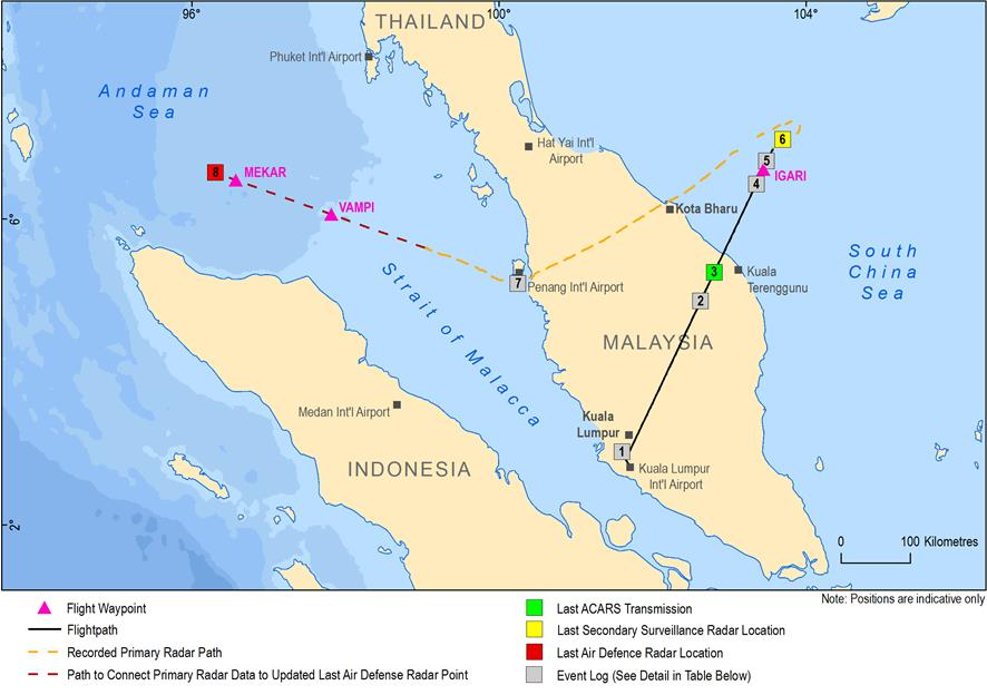
Source: The Operational Search for MH370, ATSB 2017, using Ministry of Transport Malaysia data
Manually Programmed Waypoints
This term is used to describe the data points recovered from Captain Zaharie Shah's flight simulator.
The Safety Investigation Report MH370/01/2018 used the following definition:
‘Manually programmed waypoints’ - Manually programmed waypoints are waypoints that are not published in Airway Charts