Safety Investigation Report 2018:1 Factual Information/1.1/1.1.3
SAFETY INVESTIGATION REPORT MH370 (9M-MRO)
1.1.3 Diversion from Filed Flight Plan Route
1) Malaysian Military Radar
The Military radar data provided more extensive details of what was termed as “Air Turn Back”. It became very apparent, however, that the recorded altitude and speed change “blip” to “blip” were well beyond the capability of the aircraft. It was highlighted to the Team that the altitude and speed extracted from the data are subjected to inherent error. The only useful information obtained from the Military radar was the latitude and longitude position of the aircraft as this data is reasonably accurate.
At 1721:13 UTC [0121:13 MYT] the Military radar showed the radar return of MH370 turning right but shortly after, making a constant left turn to heading of 273°, flying parallel to Airway M765 to VKB (Kota Bharu).
Between 1724:57 UTC [0124; 57 MYT] to 1737:35 UTC [0137:35 MYT] the “blip” (a spot of light on a radar screen indicating the position of a detected aircraft) made heading changes that varied between 8° and 20°, and a ground speed that varied from 451 kt to 529 kt. The Military data also recorded a significant height variation from 31,150 to 39,116 ft.
The Military data further identified the “blip” on a heading of 239° at 1737:59 UTC [0137:59 MYT] parallel to Airway B219 towards VPG (VOR Penang). Heading of this “blip” varied from 239° to 255° at a speed from 532 to 571 kt. The height of this “blip” was recorded between 24,450 ft and 47,500 ft.
At 1752:31 UTC [0152:31 MYT] the “blip” was observed to be at 10 nm south of Penang Island on a heading of 261°, speed of 525 kt and at a height of 44,700 ft.
At 1801:59 UTC [0201:59 MYT] the data showed the “blip” on a heading of 022°, speed of 492 kt and altitude at 4,800 ft. This is supported by the “blip” detected by Military radar in the area of Pulau Perak at altitude 4,800 ft at 1801:59 UTC [0201:59 MYT]. At 1803:09 UTC [0203:09 MYT] the “blip” disappeared, only to reappear at 1815:25 UTC [0215:25 MYT] until 1822:12 UTC [0222:12 MYT], about 195 nm from Butterworth, on a heading of 285°, speed of 516 kt and at an altitude of 29,500 ft.
The tracking by the Military continued as the “blip” was observed to be heading towards waypoint MEKAR on Airway N571 when it finally disappeared at 1822:12 UTC [0222:12 MYT], 10 nm after waypoint MEKAR.
On the day of the disappearance of MH370, the Military radar system recognised the ‘blip’ that appeared west after the left turn over IGARI was that of MH370. Even with the loss of SSR data, the Military long range air defence radar with Primary Surveillance Radar (PSR) capabilities affirmed that it was MH370 based on its track behaviour, characteristics and constant/continuous track pattern/trend. Therefore, the Military did not pursue to intercept the aircraft since it was ‘friendly’ and did not pose any threat to national airspace security, integrity and sovereignty.
Based on the Malaysian Military data, a reconstruction of the profile was conducted on a Boeing 777 simulator. Figure 1.1B (below) in chart form shows the Profile Chart of Data from Malaysian Military Radar. Some of the speed and height variations were not achievable even after repeated simulator sessions.
It was also noted that, in the absence of autopilot or continuous manual control, an aircraft is very unlikely to maintain straight and level flight. Further, it is extremely unlikely for an aircraft to enter and maintain a turn and then return to straight and level flight for any significant period of time.
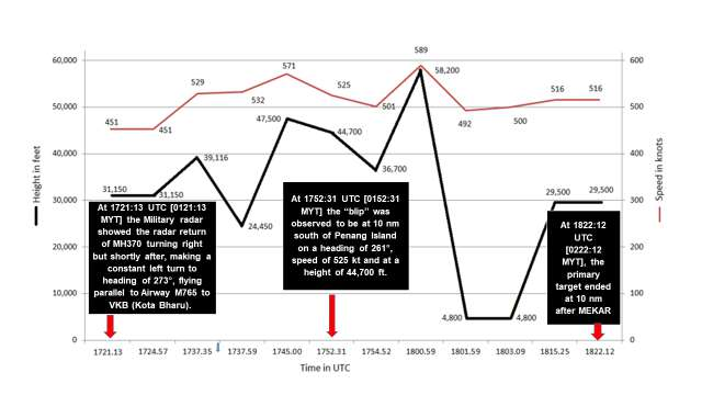
Figure 1.1B - Profile Chart of Data from Malaysian Military Radar (not to scale).
Source:
Safety Investigation Report MH370/01/2018
2) DCA Civilian Radar Data from Kota Bharu - Sultan Ismail Petra Airport Runway
The aircraft diversion from the filed flight plan route was recorded on the DCA radar playback:
- a) From 1730:37 UTC [0130:37 MYT] to 1744:52 UTC [0144:52 MYT] a primary aircraft target was captured by the Terminal Primary Approach Radar located to the south of the Kota Bharu – Sultan Ismail Petra Airport runway.
- b) The appearance of an aircraft target on the KL ACC radar display, coded as P3362, was recorded at 1730:37 UTC [0130:37 MYT] but the aircraft target disappeared from the radar display at 1737:22 UTC [0137:22 MYT].
- c) At 1738:56 UTC [0138:56 MYT] an aircraft target, coded as P3401, appeared on the KL ACC radar display and disappeared at 1744:52 UTC [0144:52 MYT].
- d) At 1747:02 UTC [0147:02 MYT] an aircraft target, coded as P3415, appeared on the KL ACC radar display but disappeared at 1748:39 UTC [0148:39 MYT], which appeared to be the continuity of the same target.
- e) At 1751:45 UTC [0151:45 MYT] an aircraft target, coded as P3426, appeared on the KL ACC radar display but disappeared at 1752:35 UTC [0152:35 MYT].
Figure 1.1C (below) shows Diversion from Filed Flight Plan Route (in pictorial form and not to scale).

Figure 1.1C - Diversion from Filed Flight Plan Route - Civilian Radar
(in pictorial form and not to scale)
Source:
Safety Investigation Report MH370/01/2018
1.1.3 (2)
It has been confirmed by DCA and its radar maintenance contractor, Advanced Air Traffic Systems (M) Sdn. Bhd. (AAT), that it was the 60 nm Terminal Primary Approach Radar, co-mounted with 200 nm monopulse SSR located to the south of Kota Bharu - Sultan Ismail Petra Airport runway, which captured the above-mentioned primary aircraft targets.
Figure 1.1D (below) shows the suitable airports for emergency en-route diversion.
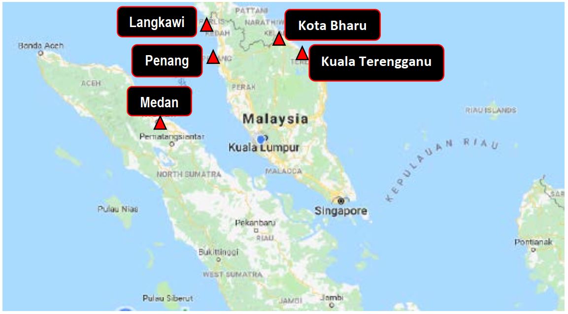
Figure 1.1D - Airports for Emergency Landing along the Flightpath of MH370 (chart not to scale)
Source:
Safety Investigation Report MH370/01/2018
1.1.3 (2)
Figure 1.1E (below) shows the Filed Flight Plan message of MH370.

Figure 1.1E - Filed Flight Plan message of MH370.
Source:
Safety Investigation Report MH370/01/2018
1.1.3 (2)
Figure 1.1F (below) shows Radar Data Plots (RDP) Tracks from the 60 nm Terminal Primary Approach Radar co-mounted with 200 nm monopulse SSR located to the south of Kota Bharu - Sultan Ismail Petra Airport runway after Diversion and Figure 1.1G (below) shows RDP Tracks from Kuala Lumpur after take-off.
All the primary aircraft targets that were recorded by the DCA radar are consistent with those of the military data that were made available to the Investigation Team.
Note: Figure not included.
Figure 1.1F - Radar Data Plots (RDP) Tracks from the 60 nm Terminal Primary Approach Radar co-mounted with 200 nm monopulse SSR located to the south of Kota Bharu - Sultan Ismail Petra Airport runway after Diversion.
Source: Advanced Air Traffic Systems (M) Sdn. Bhd. (AAT)
Note: Figure not included.
Figure 1.1G - Radar Data Plots (RDP) Tracks from Kuala Lumpur after take-off
Source: Advanced Air Traffic Systems (M) Sdn. Bhd. (AAT)
Reference:
The Malaysia Aeronautical Information Publication [AIP] ENR 1.6 dated 05 June 2008, AIP AMDT 2/2008 on the Provision of Radar Services and Procedures states that, in paragraph 1.1.4:
“In the Kuala Lumpur and Kota Kinabalu FIRs, radar services are provided using the following civil/military ATC Radars:
g) A 60 nm Terminal Primary Approach Radar co-mounted with 200 nm monopulse SSR located to the south of Kota Bharu - Sultan Ismail Petra Airport runway.”.
Figure 1.1H (below) shows the Radar Coverage Chart of Kuala Lumpur and Kota Kinabalu FIRs.
Note: Figure not included.
Figure 1.1H - Radar Coverage Chart of Kuala Lumpur and Kota Kinabalu Flight Information Regions
3) Ho Chi Minh Air Traffic Services
The tracking of MH370 was captured by HCM ACC Secondary Radar at Tan Son Nhut and at Camau Province, and Automatic Dependent Surveillance- Broadcast (ADS-B) located at Conson Island/range 270 nm) at 1711:59 UTC [0111:59 MYT] as it was heading for waypoint IGARI.
At 1720:59 UTC [0120:45 MYT] the “blip” from MH370 from both SSR and ADS-B radar position symbols disappeared from the radar display.
A visit was made to the office of the Vietnamese Civil Aviation Authority (CAAV) in Ho Chi Minh City on 10 September 2014. In interviews, the Duty HCM Duty ACC Controller who was handling MH370 on that night could not explain why he did not initiate any call to MH370 within the standard 5 minutes as specified in the Letter of Agreement (LOA) between Department of Civil Aviation Malaysia and Viet Nam Air Traffic Management dated 07 July 2001 and effective on 01 November 2001 (Refer Appendix 1.1A - Letter of Agreement between DCA Malaysia and Viet Nam). It was noted that he had only initiated an enquiry on the whereabouts of MH370 at 1739:03 UTC [0139:03 MYT] after a lapse of 12 minutes.
The Duty Controller however had stated that he had initiated calls to other aircraft on the existing frequency and on the emergency frequency of 121.5 MHz. This was neither supported nor collaborated by any documents.
The landline recorded transcripts between KL ACC and HCM ACC suggested that there were confusions on the position of MH370. This was evident when HCM ACC requested KL ACC for information on MH370 at 1739:06 UTC [0139:06 MYT]. This conversation took place:
KL ACC: “MH370 already transferred to you rite?”
HCM ACC: “Yeah…yeah…I know at time two zero but we have no just about in contact up to BITOD…we have radar lost with him…the one we have to track identified via radar.”
When pointed out that neither HCM ACC SSR nor ADS-B showed any presence of a “blip” of MH370, the Duty Controller could not explain why he mentioned BITOD.
MH370 was operating within the Singapore FIR, in that portion of the airspace which has been delegated to Malaysia (Refer to Figure 2.2K - Singapore Airspace delegated to Malaysia) for the provision of air traffic services when the last air-ground radio contact was made at 1719 UTC [0119 MYT]. As such, KL ACC should be responsible for the alerting service which would mean that KL ACC would have to declare the Distress Phase at 1827 UTC [0227 MYT] when HCM ACC informed that there had been no two-way radio communications with MH37O.
The DETRESFA was only declared at 2232 UTC [0632 MYT]. Refer to para. 2.2.7 Table 2.2C, No. 26-28 - Chronology of ATC Events following the Disappearance of MH370; and to para. 2.2.8 1) o) - Activation of Aeronautical Rescue Coordination Centre, for details.
Reference:
Manual of Air Traffic Services, Part 9 - Emergencies, para. 9-6-5, Para, 6.7.2 dated 15/3/2009 states:
If alerting service is required for an aircraft that is flight planned to operate through more than one FIR including the airspace delegate to the Kuala Lumpur and Kota Kinabalu ATSCs and the position of the aircraft is in doubt, the responsibility for co-ordinating such service shall normally rest with the ATSC of the respective FIRs:
- within which the aircraft was flying at the time of last air-ground radio contact;
- that the aircraft was about to enter when last air-ground contact was established at or close to the boundary of two FIRs or control areas;
- within which the aircraft’s intermediate stop or final destination point is located:
- 1) if the aircraft was not equipped with suitable two-way radio communication, or
- 2) was not under obligations to transmit position reports.
and
ICAO Doc 4444 ATM/501 Procedures for Air Navigation - Air Traffic Management (PANS-ATM), page 9-6, para 9.2.2.2, dated 22/11/07 states:
When alerting services is required in respect of a flight operated through more than one FIR or control area, and when the position of the aircraft is in doubt, responsibility for coordinating such service shall rest with the ATS unit of the FIR or control area within which the aircraft was flying at the time of last air-ground radio contact:
- a) that the aircraft was about to enter when last air-ground contact was established at or close to the boundary of two FIRs or control areas;
- b) within which the aircraft’s intermediate stop or final destination point is located:
- 1) if the aircraft was not equipped with suitable two-way radio communication, or
- 2) was not under obligations to transmit position reports.
Based on interviews, HCM ACC had stated that it did not initiate any emergency actions as it did not receive any change of the transfer of control time of IGARI, MH370 did not contact the Centre at the stated time, and it was unable to establish radio communication with MH370.
MH370 was also operating in the airspace delegated to KL ACC and the last air-ground radio contact was with KL ACC. Hence the provision of alerting service for MH370 rests with KL ACC.
These uncertainties were further compounded by the Duty Despatcher, based on MAS Flight Following System (FFS), who mentioned that the aircraft was over the Cambodian airspace when in fact the filed flight plan routing did not include flying over the Cambodian airspace.
Added to these confusions, for reasons best known to him, the MAS Captain from the Technical and Development Department, Flight Operations spoke to KL ACC saying that the aircraft did not leave the Malaysian airspace. When interviewed, the Captain insisted that he was asking a question rather than making a statement. This conversation was recorded at 0521.23 MYT:
KL ACC: “…had never leave Lumpur airspace?”
MAS Captain: “…yea he has not left Lumpur airspace because he has failed to call Ho Chi Minh.”
KL ACC Radar captured the disappearance of MH370 at 1721:13 UTC [0121:13 MYT]. In interviews with the Duty KL ACC Radar Controller, he stated that he did not notice the “blip” disappearance as MH370 was out of radar coverage and would be in contact with HCM ACC after the transfer of responsibility was effected.
From 1730:37 UTC [0130:37 MYT] to 1752:35 UTC [0152:35 MYT], what appeared to be MH370 was captured on KL ACC primary radar, coded as P3362, P3401, P1415, P3415
and P3426 (P signifies Primary Radar).
Figure 1.1C - Diversion from Filed Flight Plan Route.
The appearance of a “blip” coded as P3362 was recorded at 1730:37 UTC [0130:37 MYT)] but disappeared abruptly at 1737:22 UTC [0137:22 MYT].
At 1738:56 UTC [0138:56 MYT], a “blip” identified as P3401 was tracked by KL ACC but disappeared at 1744:52 UTC [0144:52 MYT].
Shortly after, another “blip” coded as P3451 appeared at 1747.02 UTC [0147:02 MYT] but disappeared at 1748:39 UTC [0148:39 MYT].
At 1751:45 UTC [0151:45 MYT], a “blip” coded as P3426 appeared south of Penang Island but disappeared at 1752:35 UTC [0152:35 MYT].
5) Medan Air Traffic Control Radar
The Medan ATC Radar has a range of 240 nm, but for unknown reasons, did not pick up any radar return bearing the SSR transponder code A2157 of MH370.
The Indonesian Military however stated that they picked up MH370 earlier as it was heading towards waypoint IGARI.
No other information was made available.
6) Bangkok Air Traffic Control Radar
The radar position symbol with SSR transponder code A2157 was detected on the Aeronautical Radio of Thailand Limited (AEROTHAI) radar display at 1711 UTC [0111 MYT] as the aircraft was tracking for waypoint IGARI.
Thailand DCA is a government agency whereas AEROTHAI is a state enterprise under the Ministry of Transport and Communications. AEROTHAI is the air navigation service provider responsible for the provision of Air Traffic Services within the Bangkok Flight Information Region (FIR).
As the flight plan of MH370 did not fall under the purview of Thailand’s FIR, Bangkok ACC did not pay attention to this flight. On playback of the radar recording it was noted that the radar position symbol of A2157 disappeared at 1721:13 UTC [0121:13 MYT].
7) Singapore Air Traffic Services
The Team visited Singapore to conduct interviews with officers from Civil Aviation Authority of Singapore (CAAS) and the Air Traffic Controllers on duty on 07 March 2014. The following were noted:
- i) Singapore ACC did not have radar coverage over the South China Sea. (ADS and CPDLC services are available to suitably equipped aircraft operating outside radar cover over the South China Sea …);
Reference:
AIP Singapore page 94 GEN 3.4-2, 10 MAR 11, para 3.2.2 d. - ii) At 2104:00 UTC [0504:00 MYT], Singapore ACC received a call from Hong Kong ACC enquiring any knowledge of a missing Malaysian aircraft MH370. Hong Kong ACC then requested assistance from Singapore ACC to contact Lumpur ACC for detailed information. It was evident that Singapore ACC was not aware of the problem until this call was received. Hong Kong ACC however had the knowledge of the missing Aircraft earlier after receiving unconfirmed information from HCM ACC;
- iii) At 2109:13 UTC [0509:13 MYT], Singapore ACC contacted Lumpur ACC to relay the query from Hong Kong ACC.
Reference
Radiotelephony transcripts between Singapore ACC and KL ACC Sector 3+5 Planner - Appendix 1.18G on Direct Line Coordination Communication, pages 109 to 114.
Source: Safety Investigation Report MH370/01/2018 Section 1.1 History of the Flight
______________________________________________
Footnotes
SSR (Secondary Surveillance Radar) - A surveillance radar system which uses transmitters/receivers system (interrogators) and transponders.