Safety Investigation Report 2018:1 Factual Information/1.1/1.1.3/1 Malaysian Military Radar
SAFETY INVESTIGATION REPORT MH370 (9M-MRO)
1) Malaysian Military Radar
The Military radar data provided more extensive details of what was termed as “Air Turn Back”. It became very apparent, however, that the recorded altitude and speed change “blip” to “blip” were well beyond the capability of the aircraft. It was highlighted to the Team that the altitude and speed extracted from the data are subjected to inherent error. The only useful information obtained from the Military radar was the latitude and longitude position of the aircraft as this data is reasonably accurate.
At 1721:13 UTC [0121:13 MYT] the Military radar showed the radar return of MH370 turning right but shortly after, making a constant left turn to heading of 273°, flying parallel to Airway M765 to VKB (Kota Bharu).
Between 1724:57 UTC [0124; 57 MYT] to 1737:35 UTC [0137:35 MYT] the “blip” (a spot of light on a radar screen indicating the position of a detected aircraft) made heading changes that varied between 8° and 20°, and a ground speed that varied from 451 kt to 529 kt. The Military data also recorded a significant height variation from 31,150 to 39,116 ft.
The Military data further identified the “blip” on a heading of 239° at 1737:59 UTC [0137:59 MYT] parallel to Airway B219 towards VPG (VOR Penang). Heading of this “blip” varied from 239° to 255° at a speed from 532 to 571 kt. The height of this “blip” was recorded between 24,450 ft and 47,500 ft.
At 1752:31 UTC [0152:31 MYT] the “blip” was observed to be at 10 nm south of Penang Island on a heading of 261°, speed of 525 kt and at a height of 44,700 ft.
At 1801:59 UTC [0201:59 MYT] the data showed the “blip” on a heading of 022°, speed of 492 kt and altitude at 4,800 ft. This is supported by the “blip” detected by Military radar in the area of Pulau Perak at altitude 4,800 ft at 1801:59 UTC [0201:59 MYT]. At 1803:09 UTC [0203:09 MYT] the “blip” disappeared, only to reappear at 1815:25 UTC [0215:25 MYT] until 1822:12 UTC [0222:12 MYT], about 195 nm from Butterworth, on a heading of 285°, speed of 516 kt and at an altitude of 29,500 ft.
The tracking by the Military continued as the “blip” was observed to be heading towards waypoint MEKAR on Airway N571 when it finally disappeared at 1822:12 UTC [0222:12 MYT], 10 nm after waypoint MEKAR.
On the day of the disappearance of MH370, the Military radar system recognised the ‘blip’ that appeared west after the left turn over IGARI was that of MH370. Even with the loss of SSR data, the Military long range air defence radar with Primary Surveillance Radar (PSR) capabilities affirmed that it was MH370 based on its track behaviour, characteristics and constant/continuous track pattern/trend. Therefore, the Military did not pursue to intercept the aircraft since it was ‘friendly’ and did not pose any threat to national airspace security, integrity and sovereignty.
Based on the Malaysian Military data, a reconstruction of the profile was conducted on a Boeing 777 simulator. Figure 1.1B (below) in chart form shows the Profile Chart of Data from Malaysian Military Radar. Some of the speed and height variations were not achievable even after repeated simulator sessions.
It was also noted that, in the absence of autopilot or continuous manual control, an aircraft is very unlikely to maintain straight and level flight. Further, it is extremely unlikely for an aircraft to enter and maintain a turn and then return to straight and level flight for any significant period of time.
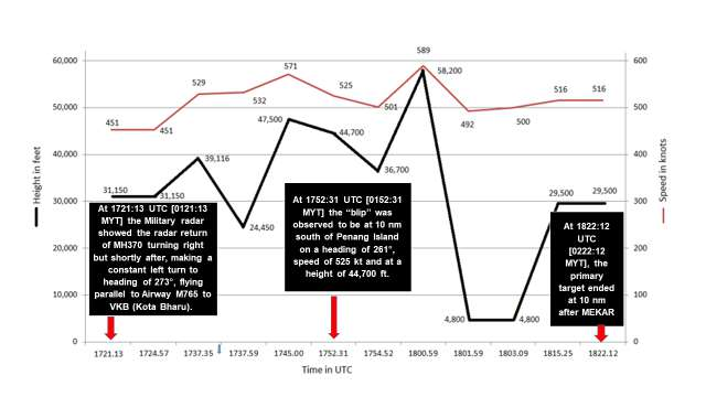
Figure 1.1B - Profile Chart of Data from Malaysian Military Radar (not to scale).
Source:
Safety Investigation Report MH370/01/2018
In the printed Report, Figure 1.1A, 1.1B, 1.1C and 1.1D are positioned on pages which may not relate to the image or diagram. Each Figure has been placed in context when importing content to this website.
Additional Information
The paper Bayesian Methods in the Search for MH370 contains some extra information about the last primary radar observation at 1822:12 UTC. The authors of this paper are from the Defence Science and Technology Group (Australia) so would have had access to data which was not made public:-
"For the accident flight, primary radar data provided by Malaysia is available from after the loss of communications up until 18:22:12. The radar data contains regular estimates of latitude, longitude and altitude at 10 s intervals from 16:42:27 to 18:01:49. A single additional latitude and longitude position was reported at 18:22:12. Figure 4.1 shows the radar data overlaid on a map. Under radar coverage, the aircraft turned sharply at approximately 17:24, crossed over Malaysia, and then turned to the North-West at 17:53."
Emphasis added.
Source: Bayesian Methods in the Search for MH370, Samuel Davey, Neil Gordon, Ian Holland, Mark Rutten and Jason Williams, © Commonwealth of Australia 2016. ISBN 978-981-10-0379-0 (eBook)
The authors collaborated on this project for the Defence Science and Technology (DST) Group (Australia) to support the Australian Transport Safety Board underwater search for MH370.